Wavy rails caused by excessive heat in Durango, Colorado
I know it’s not Phoenix, but for the Bay Area where air conditioning is a rarity, these days with temps above 100 F (38 C) are debilitating. You ride at sunrise when it’s cool, or at your peril later on.
Yesterday we did not beat the heat, as a power outage shut down our fans. Adding insult to injury, the movie we chose to watch at the local theater had no AC. So we watched another movie.
This is not the first heat event we’ve suffered through, and it won’t be the last. In 2016 our ride on the Durango to Silverton steam train came to a halt when rails buckled from the intense heat.
Today’s ride at sunrise passed several schools on McClellan Road in Cupertino at 8:10 a.m. I’ve never seen so many pedestrians, cyclists, and cars competing for space.
Now I understand even better than before why a Class IV separated bike lane was built. Use extreme caution riding here at this time of day. It’s chaos.
We all know teens are less safe than other drivers, and they’re just as bad when it comes to cycling.
But it didn’t stop there. I rode past Apple’s spaceship HQ, and it happened to be the company’s annual announcement day, this time for the iPhone 14. More traffic, but few bikes.
As I rode home, I avoided busy Pruneridge in favor of Mauricia Avenue, taking Harvard, Calvert, Tracy, foot bridge over Saratoga Creek.
That’s a sentiment expressed by Santa Clara City Council member Kevin Park at the recent Pruneridge bike lane meeting (3:06 into recording). He would like to see no bikes on busy roads, and bikes on less traveled roads.
That’s wishful thinking. It’s often inconvenient and time-consuming for a cyclist to pursue that kind of trip planning.
A chicane we can do without over Saratoga Creek in Santa Clara.
But I have plenty of time and I like to avoid cars, so I will take side streets when it’s convenient.
There’s nothing convenient about the bridge over Saratoga Creek (see photo). It cries out: “No bikes here.” If we want cyclists to use side streets, we have to do better.
Palo Alto had the same situation with a creek crossing and eliminated the barricade fence, after decades. At least they took action.
I’ll summarize the options presented to the Santa Clara City Council regarding adding bike lanes on Pruneridge Avenue.
Do nothing: Everything stays the same.
Concept 1: Four lanes, removing parking on one side to accommodate buffered bike lanes five feet wide.
Concept 2: Two travel lanes and a center two-way left turn lane, buffered bike lanes. Curb extensions and high-visibility crosswalks at select intersection locations. Parking on both sides of roadway. Includes two eastbound through lanes between San Tomas and Saratoga with the outer lane becoming a right-turn lane at Saratoga.
Concept 3: Parking protected separated bikeway. Two travel lanes, parking on both sides, but providing separation for cyclists by moving parking away from the curb. Curb extensions, high-visibility crosswalks.
Concept 4, hybrid: Concept 2, but transition back to four traffic lanes between Tanoak Drive and Harold Avenue to accommodate cars accessing San Tomas Expressway. Bike lanes will be 5 feet wide with a 2-foot buffer (instead of 3 feet as in Concept 2).
My assessment follows:
Concept 1
Concept 1: The Pruneridge plan’s goal is to make driving, cycling, and pedestrian travel safer. Keeping four travel lanes does nothing for driving or pedestrians, and is only marginally better for cycling. It removes all parking along Pruneridge, a residential neighborhood. (As an aside, I would never park on Pruneridge, were I to live there. I witnessed a truck rear-end a car parked on Pruneridge. The driver was drunk and fell asleep at the wheel. The homeowner said that was the second time his car was rear-ended.)
Concept 2
Concept 2: This is the alignment on Pruneridge west of Pomeroy and the length of W. Hedding Street. It satisfies the goal of the Pruneridge plan to make travel safer. With eight feet separation (bike lane and and buffer) there’s room for the various human-powered and electric-powered vehicles to maneuver. We will see a lot more e-bikes, e-scooters, and other vehicles in the future, so the extra space is needed.
Concept 3
Concept 3: This is a variation on Concept 2, but parking is moved away from the curb to create a buffer between bikes and vehicle traffic. My experience with this alignment on 10th Street in San Jose (a one-way street) is negative. I felt like I was not part of the traffic, hidden by cars. There could be garbage cans in the bike lane. Pedestrians will not be as aware of bikes in this location. Street cleaning is problematic. Cars might not park properly. Finally, when I needed to turn left I had to leave the bike lane through a gap in parked cars. That’s dangerous.
Concept 4 hybrid
Concept 4, hybrid: This plan is a variation on Concept 2 to provide easier car access to San Tomas Expressway from Pruneridge. There are four car lanes between Harold and Tanoak Drive. I’m concerned that there will not be much of a buffer between cars here. I’ve had many encounters with cars turning right onto San Tomas when I’m eastbound, and the same for westbound. Drivers tend to be in a hurry and they’re unaccustomed to seeing bikes in their way at a busy intersection.
I don’t have an easy answer for the San Tomas Expressway intersection. I don’t think Concept 4 will do much to reduce bike/car encounters. Pedestrians need to use caution at the right-turn lanes. Concept 2 would be better for bikes, but worse for cars. In think this stretch of Pruneridge will still feel like a dangerous undertaking for bikes, but not as bad as it is now with no bike lanes.
My Concept 5: I’m hoping that self-driving cars will make our roads safer and improve traffic flow. I’m confident it will happen…one of these days.
Accidents: red (pedestrian); yellow (bicycle), blue (vehicles)
Follow-up to Santa Clara city’s approval of bike lanes on Pruneridge Avenue:
Santa Clara’s street department is thorough, if nothing else. The Pruneridge Avenue study for bicycle lanes consumes about 50 MB of space. That’s a lot. PDF Packet
It’s so much that all but the most dedicated will glaze over the interesting and valuable data.
I’m going to mine the study and shed light on some valuable nuggets of information, so here goes.
There were 60 collisions on Pruneridge (Winchester to Pomeroy) between January 2015 and December 2021, one fatal (vehicles).
Four collisions involved bicycles, and three involved a pedestrian.
Fifteen percent of vehicles traveling on Pruneridge drive faster than 34-41 mph, considered an acceptable range.
The project will cost between $3.8 million and $8.3 million (2022 dollars). I’m guessing the hybrid plan will fall midway between the high and low estimate.
The restriped section of Pruneridge quadrupled bicycle traffic, reduced weekday car traffic by 5 percent, and reduced car collisions by 15 percent.
About 15,000 vehicles travel on Pruneridge (pre-Covid) daily, split equally between west and east. Traffic is now 45 percent lower compared to pre-Covid.
Pruneridge Avenue in Santa Clara will be restriped for bike lanes.
And you thought it would never happen. Tuesday evening Santa Clara City Council approved a city plan to restripe Pruneridge Avenue for bicycle lanes from Winchester to Pomeroy.
Now the city can seek funding, so it won’t happen right away.
First, some history. In 2012 Santa Clara dipped a toe in the water and reconfigured Pruneridge Avenue between Pomeroy Avenue and Tantau Avenue, in Cupertino. It went from four lanes to two lanes with a center turn lane and bike lanes (known as Concept 2 in the report).
I think this transformation predates Hedding’s restripe to two lanes from four.
I’m told that the Pruneridge change didn’t sit well with many residents, but nobody likes change, so I’m not surprised.
Pre Covid I will admit the expressway intersections (Lawrence, San Tomas) became a source of frustration for drivers, with waits up to three turn signals during rush hour.
Post Covid, I’m seeing little to no congestion on our roads, and I ride at all times of the day. I think lighter traffic is the new normal.
Meanwhile, San Jose converted Hedding Street to two lanes with a center turn lane and bike lanes in 2014, finishing the entire length in 2017.
I’ve ridden Hedding many times since the transition and it is by far the safest and most enjoyable east-west route across north San Jose.
Santa Clara has always intended to add bike lanes the length of Pruneridge, at least that’s true if you believe their city bike plan, as well as the Santa Clara County bike plan.
The city street planning department, working with a consultant, presented at least five options during the City Council meeting.
There were a few nitpicks from some council members, but generally they seemed to be OK with all of the plans, except doing nothing, so that was a positive step.
Settling on the exact plan took the most time.
Karen Hardy, city council member and chair of the Santa Clara Bicycle and Pedestrian Advisory Committee (BPAC), took the lead and recommended the hybrid plan, called Concept 4. She said that BPAC recommended that configuration, but they also liked Concept 2, the same design as Hedding and the existing Pruneridge section.
Concept 4 example (Alta Planning + Design)
City Engineer Michael Liw gave a long-winded explanation as to why this plan might work best. San Tomas has a double-left turn lane onto Pruneridge eastbound. The county doesn’t want to lose that configuration. That’s the gist of it.
So, the Hybrid Plan is to have four lanes between Tanoak Drive and Harold Avenue, plus bike lanes, plus a center turn lane. I’m keeping an open mind, but it sure seems like there isn’t enough room.
The rest of Pruneridge follows Concept 2.
Some parking will be eliminated on Pruneridge between Harold Avenue and Saratoga Avenue. I don’t think too many people will miss cars parked in this congested area. My motorist side is breathing a sigh of relief.
The rest of Pruneridge where there has been parking, will not lose any parking.
The council agreed to adopt the Hybrid plan without much more debate. Kathy Watanabe – no; Karen Hardy – yes; Kevin Park – yes; Suds Jain – yes; Anthony Becker – yes; Mayor Lisa Gillmor – recused herself since she lives close to Pruneridge; Raj Chahal – absent (family emergency).
Something else might have been at play that helped the Pruneridge bike lane. The city of Santa Clara is embroiled in Levi Stadium issues. I don’t fully understand all the behind-the-scenes maneuvering, but suffice it to say, everyone on the council must have been drained from the earlier meeting on that issue, which went 45 minutes over the scheduled time.
There was also a lot of favorable public input. I want to call special attention to Vincent Chen, a Santa Clara high school student. He gave an impassioned two-minute speech via phone that amazed me for its eloquence. This guy is going places! Start listening at 3:29:50.
Final thoughts
I’m ecstatic that Pruneridge will have bike lanes. I’ve spent the past thirty years hoping for this day. There will also be pedestrian improvements, which can be found in the full presentation, Packet 1, in PDF.
I prefer Concept 2 over the Hybrid plan, and here’s why. The section that will be four lanes is where there’s the most congestion, thanks to motorists wanting to use San Tomas Expressway. I can’t tell you how many times cars have buzzed me as I rode past the Pruneridge golf course, most of them speeding.
I don’t think a white stripe is going to help much as cars speed by only inches away. Concept 2 gives a comfortable buffer.
I’m open minded though. I’ll praise the Hybrid plan to the heavens if it works out to my satisfaction.
In the meantime, I’ll continue using Los Padres/Forbes on my westward rides.
I posted this blog on my Geocities site years ago, but somehow it didn’t make the transition to WordPress:
I’ve been fascinated by cyclometers since childhood. I wished I had one of those neat mechanical clickers that hooked to the front wheel and measured mileage. That was the early 1960s.
Over the years I saw more mechanical cyclometers — big and clunky — and I wanted nothing to do with them. I had discovered lightweight racing bikes, and the thought of having one of those had no appeal.
By the late 1970s I started seeing electronic bike computers. There were still big and clunky.
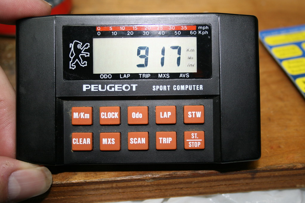
Avocet cyclometer In 1984 all that changed. I was working at Palo Alto Bicycles in downtown Palo Alto, California. Nearby, a small bicycle company called Avocet had big plans for a small “cyclometer,” a word trademarked by the company. This was the first U.S. company to compete against the small CatEye bike computer, which was made in Japan and introduced in 1981.
A lot of great ideas and innovations came from Avocet — gel saddles, polypropylene bike clothing, touring shoes, smooth tires, and the ultimate bike gizmo — a small cyclometer. I mean small, about 2 1/8 by 1 7/8 inches. It showed speed, distance, time. That was enough then. And it was accurate.
I had the privilege of carrying a “boat” of wafers to a local fab manufacturing the chip, a custom gate array that was the brains of the cyclometer. Little did I know then I would one day work for National Semiconductor and that one of the later engineers of the Avocet cyclometer would one day work there too.
In those days, I worked in mail order and I would ship out the first Avocet cyclometers in the summer of 1984. The ads started early, a little too early as it turned out (1983 when only a few prototypes were working). The first cyclometers had problems. This was cutting-edge technology in 1983 and Avocet was hardly a big, rich company. Eventually, they worked out the bugs and the Made in USA cyclometer became a “huge” success. Greg LeMond used one in his racing days and so did most of the pro teams.
Pretty soon a bevy of companies sold cyclometers. Avocet introduced new models in a rainbow of colors. They were sleek, had more functions, and no bike was complete without one.
Avocet set another milestone in the mid 1990s with the Avocet 50, the first cyclometer to introduce an altimeter and cumulative climb. Its patented accumulator did not add small bumps in the road or short-term atmospheric changes, the bane of atmospheric altimeter accumulators.
Avocet stopped making cyclometers, but there is no shortage of other companies making them.
Specialized Speedzone Pro In 2003, I learned about the Specialized Speedzone Pro, which had all the functions a cyclist could ask for, at least a cyclist living in the San Francisco Bay Area who liked riding in the hills − gradient, altimeter, cumulative climb, distance, speed, max speed, average speed, temperature. Kilometers, Miles, Centigrade, Fahrenheit. A night light. You name it, the Speedzone Pro had it.
I had to have one. I bought mine at Cupertino Bike Shop for $100. Specialized did everything right, down to the packaging. It came in a small black metal box, a miniature version of the lunch box I carried to school as a child. Brilliant.
That cyclometer answered questions and confirmed long-held beliefs, especially gradient. I had a general idea of the gradients of some of the steeper hills, having measured them with a 100-inch aluminum beam. Pretty crazy. I drove around with that aluminum beam sticking out the back of my 1976 Datsun B210 hatchback, stopping at steep places to measure. My measurements wound up on the WWW in 1995 and generated quite a bit of interest.
The Speedzone Pro gave the cumulative climb for the 102-mile Mt. Hamilton ride, about 8,000 feet. It showed a 20 percent grade on parts of Sonora Pass. I knew how cold it could get — 28 degrees one morning riding to work in late 2006. I found out 60 mph can be reached on Tioga Pass, if you’re brave.
The Speedzone Pro never failed, until November 11, 2007. I hadn’t pressed the night light in a long, long time. When I pressed it the cyclometer blanked out. Had it shorted out? I removed the battery and reinserted it. It was back to normal. What a relief.
The Speedzone Pro is no longer sold by Specialized. Other brands with similar features are sold, but they aren’t cheap. (Mine still works.)
Making a repair Just two days later another disaster overtook the Pro. The right button for “cycling” through the functions stopped working. It was stuck on time of day. I heard that this was a failing of the Speedzone Pro. I hoped the day would never come, but it did.
With no other option but open-case surgery, I carefully pried it open. It wasn’t easy. Some glue held it together. I used a small pocket knife, working it a little at a time until the case finally popped and separated.
I took apart the case and found the culprit. The button − a small, round plastic plunger − fit through a square sliver of sprung steel. The metal cracked from use, so no more spring action.
Finding a matching piece of metal would be a miracle. I wandered around the house looking for something, anything that might work. I spied a ballpoint pen spring and wondered if the plastic plunger would fit inside the spring. A perfect fit! I just had to size the spring, insert the plunger and reassemble. It worked!
I can’t fault the manufacturer. Nothing lasts forever. Anyway, this Speedzone Pro lives on to enjoy another adventure ride somewhere in the wilds of the Santa Cruz Mountains. Every cyclometer should be so lucky.
Ride with GPS offers a customizable dashboard. Easy on the eyes.
After using a smartphone, I can compare it against bike computers. I don’t think one is better than the other.
Both devices have advantages and disadvantages. Smartphones open up possibilities, not found in bike computers.
They also raise the stakes in the event of a fall. In all likelihood, your phone will be destroyed or damaged.
On rocky trails, or extremely bumpy roads, your phone might go flying.
Don’t rule out water intrusion. I spilled a small amount of water from my water bottle onto my iPhone Touch. It was toast.
If all you care about is speed, distance, time, buy a bike computer. Some computers use GPS, giving you altitude and gradient. There are also a handful of computers that offer those functions in hardware, without GPS.
Lots of today’s bike computers also track your heart rate, cadence, power output, and more. You can upload the data to a computer or an app. They offer maps and directional uploads, too.
A smartphone can do just about anything a bike computer can do, even the ones that have all the bells and whistles.
They’re like Swiss army knives though. They work but they’re not the best solution. They’re also bulky.
A smartphone can answer your questions as you’re riding along. That’s neat. Or you can listen to a podcast.
Now we’re getting into the realm of distracted driving.
As for visibility, my screen sits at an angle. The view isn’t great, mainly because I don’t have a bright screen. OLEDs might give better results.
You’ll find a handful of bicycle dashboard apps. I tried one that looked promising, but the MPH was way off.
The most reliable apps are Strava and Ride with GPS. They work great and can be customized.
Ride with GPS, in my experience, is within a few tenths of a mile compared to a traditional bike computer and Garmin Edge 500.
Now that I know all my routes, I don’t have much need for a bike computer.
A smartphone is a different matter. I carry one for emergencies. So I figured I might as well take it out of my back pocket and mount it where I can get some more use out of it.
It’s the way to go, until you burn through your battery. Sigh.
Nice new bridge over Burns Creek. I think it was a culvert before.
I shudder to think how much money our governments spent so I could do today’s ride in the Santa Cruz Mountains.
I am forever grateful, and this column is dedicated to all who made the ride possible.
As you know, in the wet 2016-17 winter Redwood Lodge Road and Schulties Road, located near Summit Road, took a pounding. A bridge was wiped out and two slides blocked the roads.
I managed to get through in 2019 (see column) despite these problems, but then I learned the roads were fixed recently.
I had to see for myself.
Sure enough, the roads are open again. There are repairs being made even now on Schulties Road.
The handful of people who live on Schulties must be so thankful that anyone would even think of them. The road has turned to dirt after being paved in the 1930s or so.
The bridge over Burns Creek looks top-notch. Once upon a time I walked up that creek to find the south portal of Wrights train tunnel. Today the creek is so low there’s no need to be concerned about wet feet.
While I’d never recommend trying these roads, unless you have a true sense of adventure, their existence truly amazes me, only miles from the crowded and high-tech Silicon Valley.
Slide fixed after crossing Burns Creek.Schulties Road repaired. Had to walk on a narrow plank across a chasm before fix.
Cupertino Bike Shop from the early 2000s on S. DeAnza Blvd.
When you’ve been around for a while, you start to realize nothing is forever, including bike shops. I read on their Facebook page that the Cupertino Bike Shop is closing at the end of August.
Vance Sprock took over the shop more than 30 years ago, which was founded out of the Cupertino home of Spence Wolfe in 1953. His shop was one of the first in the Bay Area to sell European imports like the venerable Cinelli.
Vance still has the original receipts from back then, with prices that make your head spin. $150 for a complete bike with the latest Campagnolo components.
Vance says he’s closing because rents have skyrocketed. No surprise there. Bike shops can’t charge high prices, as such a high rent would require.
So they’re going out of business all over the country, especially in the expensive Bay Area.
That’s bad news for cyclists. Sure, you can buy your parts online, but what if you need someone to assemble your bike, or fix something? Good luck with that.
I occasionally have to visit a bike shop for an intricate repair, or to buy a hard-to-find part. Pretty soon that task will become problematic.
I don’t know what the future holds, but cyclists will adapt. Maybe mechanics will freelance. There are a handful of mobile mechanics eeking out a living.
I haven’t been to a bike shop in two years, mostly because my bike riding days are winding down.
One aspiration in my youth was to work at a bike shop. That dream came true, so at least I have fond memories.
It was everything I feared, and then some. Big Basin Redwoods State Park has reopened for all to see the catastrophic destruction wrought by a freak lightning storm in August 2020.
In the span of 12 hours, 95 percent of the park burned (as well as Butano State Park), killing thousands upon thousands of trees, mostly Douglas fir, tanoak, madrone, and more. Not to mention wildlife.
View entering the park from Boulder Creek.Headquarters a memory.
Redwoods have found ways to survive fires, and most of them will recover. Signs of new growth are evident everywhere you look.
Approaching from Boulder Creek on Hwy 236, I started noticing scorched trees a couple miles out of town. The Boulder Creek Golf and Country Club was spared, but some surrounding neighborhoods were not. Fire is fickle.
The old park headquarters and general store were completely destroyed. All that’s left, ironically, is concrete and pavement. It looks just as it did when I last visited.
Parking remains the same.
Cars need to make a reservation, but cyclists can visit without a reservation.
Most of Gazos Creek Road is open, but the North Escape Road is closed. Hwy 236 is open, but China Grade, going north, is closed.
Some popular trails near the old headquarters are open.
I visited on a Monday, so traffic was light.
It’s worth a visit to see the forest and how it’s recovering. The views, which were few before the fire, show the landscape in all its tragic glory.
View from 236 toward North Escape Road.
Hwy 236 was spared from about 1.5 miles before the Hwy 9 intersection. It’s a noticeable contrast in shade compared to the burned sections. I always appreciated the road for the abundant shade.
Other items:
Summit Road from Black Road to Bear Creek Road has been repaved and has new fog lines. Fabulous.
Bear Creek Road is good for descending in the AM, when most traffic is headed to the Valley.
A new Big Basin Redwoods HQ is planned at Saddle Mountain near Little Basin Road.
Just off the busy Interstate 80 at Donner Summit there’s a quiet two-lane road that winds precipitously down to Donner Lake and the town of Truckee. Not so obvious is an old railroad grade that parallels the road.
These days a handful of drivers pull off the freeway to explore the railroad grade, which keeps a gentle slope thanks to a series of tunnels carved in granite by industrious Chinese laborers in 1867.
It’s difficult to appreciate the obstacles they had to overcome, and there were many: altitude, cold, snow, unyielding rock, discrimination, explosives. But they persevered and the transcontinental railroad united the country in 1869.
We stopped by for a second look in late June, only to find that the road past the scenic Donner Memorial Bridge was under construction. That turned out to be a godsend.
We turned around and searched for the entrance to tunnel 6 — at 1659 feet, the longest of several tunnels at the summit. I missed it last time and wanted to see if it was still open.
After a brief search we found the west portal, which is conveniently located in a wide, flat dirt area off Sugar Bowl Road. Of course, it will be snowed in most winters.
We walked inside the tunnel, which looks much like it did when completed in 1868, except for the annoying graffiti. Water drips from above at a steady rate, keeping the floor wet year around. The railroad ties and rails were removed when Union Pacific abandoned this route in 1993.
A short distance farther east at the Summit Haus you’ll find some artifacts from the railroad days. Midway between the east and west portal of tunnel 6, a vertical shaft was dug so that workers could attack the tunnel from four points.
It was no easy task to dig the shaft. Engineers converted a railroad steam engine into a “donkey” for hauling rock to the surface.
The shaft is still there, covered by a rusty steel plate, close by some interpretive signs.
Seeing the tunnels and walking through them gives you a better appreciation of the engineering challenge workers faced.
I also had the good fortune of taking Amtrak through the tunnels in the mid 1980s. At the time, I had no knowledge of their history.
China wall at tunnel 8 west portalTunnel 6 memorial plaqueTunnels 6, 7, and 8 looking eastTunnel 6 vertical shaftTunnel 6 west portal


You must be logged in to post a comment.